MercoPress. South Atlantic News Agency


The postage stamp war for the Falkland Islands
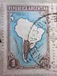 Fig. 1
 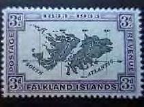 Fig. 2
  Fig, 3
 Albert-Friedrich Gruene of the Falkland Island Philatelic Study Group offers a fascinating insight into Britain and Argentina’s use of the postage stamp over the past 77 years in an illustrated ‘battle’ for the Falklands. The article was published in Penguin News.
Argentina has issued in recent years quite a number of commemorative stamps, special cancellations and vignettes showing the Falkland Islands as part of the territory of Argentina.
This ‘tradition’ began on January 1, 1936, when the Argentine Postal Authorities issued a one peso map stamp (Fig 1) clearly showing the Falkland Islands as part of Argentine territory.
The British reaction came swift in February 1936 when Anthony Eden, the then Foreign Secretary, stated in the House of Commons: “The British Ambassador at Buenos Aires had been instructed to protest against the inclusion of the Falkland Islands in this map stamp of Argentine Territory, and to inform the Argentine Government that HM Government cannot admit the claim that the Islands are Argentine property.”
The origin of the Argentine one peso map stamp issue dates back to the January 2, 1933, when the legendary Centenary stamps of the Falkland Islands were issued (Fig 2) which were refused by the Argentine Republic and led to a kind of ‘postal war’.
Maude Carey the then postmaster of the Falkland Islands and the first lady Postmaster of the British Empire wrote to a collector in 1933: “There seems to be much disturbance going on in Argentina and I believe according to the paper ‘La Prensa’ intend surcharging any of our letters which bear the Centenary stamps. They’ve got the impertinence to claim the Islands. I’ve just written to someone there to see what will happen to my envelopes.”
Mail franked with stamps from the Centenary issue were charged postal dues as for un-stamped mail and in some cases the stamps were obliterated; much sought after collectors’ items nowadays!
When the Argentine authorities issued in 1936 their one peso map stamp they were obviously not aware that the British Empire had made a territorial claim on a map stamp already 38 years earlier in December 1898, when Canada issued a commemorative stamp that is known among collectors as the ‘Map Stamp’, but also as the world’s first ‘Christmas stamp’ (Fig 3).
The initiator of the new Canadian stamp for the Imperial Penny Postage rate (1d=two Canadian cents), Sir William Mulock, the Postmaster General of Canada, wished for a so called Mercator projection (a cylindrical map projection presented by the Flemish geographer and cartographer Gerardus Mercator in 1569), that showed the earth as if it were flat.
So Sir William consulted George R Parkin who had published in 1893 his famous ‘The British Empire Map of the World on Mercator’s Projection’. Parkin was then the most important protagonist of a united British Empire (at least on his maps). He attempted to demonstrate the reconstruction of the world by modern technology and tried to create the impression of an organic unity of the British Empire by the professional marking of naval bases, railways, telegraph lines and steamer routes on his maps.
Parkins proposal of ‘a miniature reproduction of his map of the British Empire with Canada in the centre’ was soon accepted.
Two main varieties of this stamp exist; half of the total printing of 20 million was printed with blue oceans and the other half with green oceans. The countries that belonged to the British Empire were printed in red. At that time Britain held the largest empire on earth and that explains the slogan at the bottom of the stamp, “WE HOLD A VASTER EMPIRE THAN HAS BEEN” (borrowed from an 1887 poem of Sir Lew Morris).
Parts of German South West Africa, German East Africa, the Republics of Transvaal and the Orange Free State, Portuguese East Africa and the island of Borneo plus some more countries (or at least parts of them) were also by accident included in the British Empire with the result that the empire became a bit VASTER than in reality.
If you look on the red colour (darker shading for print as opposed to online readers) in the Falklands vicinity, the map indeed looks already very modern.
One could think that the Total Exclusion Zone an area that was declared by the United Kingdom on April 30, 1982 covering a circle of 200 nautical miles (370 km) from the centre of the Falkland Islands was already anticipated 115 years ago!
I think it is clear by now why the stamp is called among collectors the ‘Map Stamp’; actually I think it is also the world’s first ‘Map Stamp’ showing for the first time a map of the whole world on a postage stamp. One important question is still open: Why is it also called by many collectors the First Christmas Stamp?
The best explanation I found comes from Michael T Nowlan: Stamp designs for the colonial countries had to be approved by the ruling monarch (in 1898 by Queen Victoria.) When a post office official was presenting the new Canadian stamp for the Imperial Penny Postage rate, he suggested to Her Majesty that the new stamp could serve as a tribute to the prince. The official was referring to the then Prince of Wales (three years later King Edward VII) whose birthday occurred on November 9, the date originally selected for the release of the issue.
Queen Victoria is said to have replied, “Which prince?” in a tone that made clear she would not be pleased with a royal connection other than herself. The official replied swiftly “the Prince of Peace” referring to the Christ child. As a result, the stamp when it was officially released on December 7, 1898, bore also the words ‘XMAS 1898’.
Apart from the discussed interesting peculiarities of the issue, one thing is clear; it is not only the first Map Stamp, the first Christmas Stamp, but it is also the first postage stamp that claims the Falkland Islands for the British Empire.
When Les Hardy a Falklands resident privately produced a postcard in 1933 showing a map of Falklands he knew which flag he had to use on the top of his card - the British flag.

Top Comments
Disclaimer & comment rules-

-

-

Read all comments'They’ve got the impertinence to claim the Islands'
Feb 18th, 2013 - 07:33 am 0Nothing changes, but this was all finally SORTED out in 1982 and Argentinas impertinence well and truly STAMPED on.
My favourite photo from my Falklands visit some years ago is self and partner on the steps of the Stanley Post Office, with the post office sign with its prominent crown over our heads, and red pillar box and phone booths just on one side. It beautifully captures the flavour of the place. No doubt most tourists to the Falklands have precisely the same photo.
Feb 18th, 2013 - 09:56 am 0They just thought that they could get away with it.
Feb 18th, 2013 - 10:01 am 0They would claim anything if they thought no one would miss it!
l'm surprised that they haven't claimed the Philippines.
The Philippines were Spanish 350 years, maybe Argentina “inherited” them from Spain. lol
Commenting for this story is now closed.
If you have a Facebook account, become a fan and comment on our Facebook Page!