MercoPress. South Atlantic News Agency


Argentina now takes Falklands’ dispute to satellite imagery
 The state of the art “Leiv Eiriksson” is drilling in Falklands’ government licensed areas
 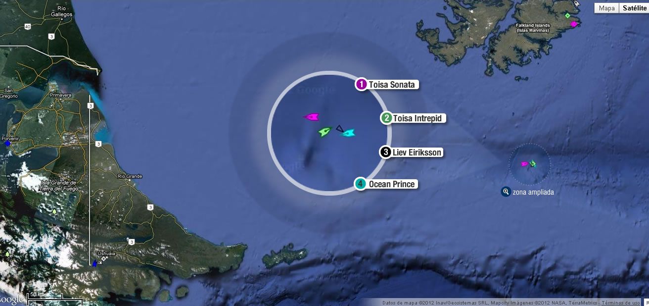 Satellite image of the alleged incursion in Argentina’s EEZ
 The Argentine newspaper Ambito Financiero reported on Friday, without revealing sources, that oil exploration rig Leiv Eiriksson, contracted by two oil companies to drill to the south of the Falkland Islands “was found, on Thursday, exploring in Argentine waters”, according to ‘irrefutable’ satellite images.
However Falklands oil industry sources downplayed the news and said that oil rig deployment in the Islands’ water is quite different from what is published from Buenos Aires. “We are quite used to Argentine misinformation and imagination”.
Furthermore “there is a lot of artistic licence put into that (satellite) image - reality is quite different”.
Ambito reports that the Bahamas flagged rig (120 metres long and 89 metres above sea level), together with the Toisa Intrepid and the multipurpose Toisa Sonat “at the end of last month were located very close to the 200 miles from the Argentine continental shelf, which caused alarm among (Argentine) authorities”. Later a third Norwegian flagged salvage vessel, “Ocean Prince”, joined the group.
However, “in recent days both the Leiv Eiriksson and its accompanying vessels violated the borders of Argentina’s Economic Exclusion Zone, EEZ”, having advanced “between 8 to 10 nautical miles beyond the pre-determined limits, to 190 miles off the Argentine coast”, based on images from the Mompesat satellite monitoring system to which “Ambito had access”.
“The oil rig and companion ships spent over 90 hours in that location exploring or carrying out exploratory tasks, which led to speculation that the company is considering a third well, located within Argentine territorial waters”.
“Irrefutable satellite images, reports Ambito, show that on Wednesday the platform was located at the coordinates -53°59’54’7 south -58°76’51’1 west. However, by midday yesterday (Thursday) it had retreated and briefly sailed toward the Islands before dropping anchor at 53°35’44’63 south and 58°45’55’13 west. According to sources with access to the Mompesat satellite monitoring system, the positioning of the platform was brought to the attention of the authorities”.
Ambito continues: “in recent months we detected that they were on the point of violating our economic exclusion zone and for this reason we have been constantly monitoring” said the source.
Meanwhile, sources linked to the Argentine Foreign Affairs Ministry confirmed that this “is not the first time that an oil rig violates the zone limits, although it is the first time that this has happened since the diplomatic conflict bubbled to the surface in January”. According to those sources, “the Ocean Guardian, exploring to the north of the archipelago since 2010 is (was) also positioned within Argentina's continental shelf”.
However the article also partly explains a possible cause for the different interpretation of the limits of the adjoining EEZs.
“For the Argentine state, according to the presentation by COPLA (National Committee for the Exterior Limit of the Continental Shelf) to the United Nations, the continental shelf of a bordering state includes the sea bed and sub-marine layers which extend beyond its territorial sea and across the length of the natural extension of its territory to the outer border of the continental margin, or to a distance of 200 miles counted from the base lines from which the borders of the territorial sea are measured, when the outer border of the continental margin does not reach the same distance.“
However, this position conflicts with the United Kingdom, who, taking the ”bordering state” to be the Falklands/Malvinas Islands, consider a large part of the waters around the Islands to be their EEZ.
The Leiv Eiriksson rig was contracted by Borders & Southern Plc and Falkland Oil and Gas Ltd, both companies licensed by the Falkland Islands government to explore in its jurisdictional waters.
Ambito says that the Argentine Foreign Affairs minister has sent notes of discouragement to the companies involved: to oil companies as well as the accompanying ships and support vessels. But also admits frustration at the lack of echo from the different complaints the Argentine government has sent out, and admits a fundamental problem: “It is the ‘kelper’ (Falklands’) government which awards the exploration licenses and therefore the complaint should be addressed to them, but doing so would in some way acknowledge sovereignty which contradicts the basic (sovereignty) claim”.
Ambito Financiero, a much respected Argentine financial publication following the death of its founder in 2006, finally ended in the hands of Editors Amfin, belonging to Orlando Vignatti, a media investor. Reporting quality remains but far from when it became a reference for the financial community. The group also owns the Buenos Aires Herald.

Top Comments
Disclaimer & comment rules-

-

-

Read all commentsThis simply gets better and better..... :-)
Feb 18th, 2012 - 12:37 am 0Not only are the FI potentially sitting on $180b of oil but they might even be drilling it from RG territory.....ha, ha, ROFL.....
Its time the RG military got the rowing boat, glider and pea shooter out.
More Argie government propaganda, and not written by a professional navigator it seems - it isn't possible have 76 minutes of anything in lat/long position!
Feb 18th, 2012 - 12:39 am 0Moreover, if you look at the picture it is obvious that everything in that cluster is much nearer to the Falklands than to Argentina, so I suppose that means they are talking bollocks as usual because that would put it well inside the Falklands exclusion zone and not anywhere near the Argie one.
Give up. It isn't yours and never will be. Get over it.
This propaganda will clearly be on banners in Argieland as we speak, getting the locals really upset because someone is actually managing to get hydrocarbons out of the ground, when they're not able to.
Feb 18th, 2012 - 12:44 am 0“Peronism says that this is within 200 miles of the blah blah blah blah blah” You walked out of talks on oil discovery and fishing, so just go into the corner and be butthurt.
Commenting for this story is now closed.
If you have a Facebook account, become a fan and comment on our Facebook Page!