MercoPress. South Atlantic News Agency


NASA satellites image Haiti areas hardest hits by the earthquake
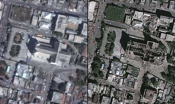 Before and after scenes of Port-au-Prince help with damage assessment
 NASA's considerable Earth-observing and data analysis and distribution capabilities have been mobilized to provide information to support disaster recovery efforts in Haiti after the devastating Jan. 12 earthquake.
NASA has tasked two of its space-based, high-resolution instruments to image areas hardest hit by the earthquake. Before-and-after scenes of Port-au-Prince, for example, will be used to aid with damage assessment and recovery.
The Advanced Spaceborne Thermal Emission and Reflection Radiometer (ASTER), a Japanese-U.S. instrument with visible, infrared and thermal infrared sensors flying on the Terra spacecraft, took observations of the region on January 14.
The data are being processed and compared with pre-earthquake imagery. ASTER will again revisit the area on Jan. 19 and Jan. 21.
NASA's Earth Observing-1 (EO-1) satellite was scheduled to obtain multi-spectral images of the region on Thursday Friday January 15.
NASA and the NASA-funded SERVIR Rapid Response Mapping team at the Centre for Water in the Humid Tropics in Latin America and the Caribbean are on standby to support the damage assessment efforts once EO-1 and ASTER data are available.
NASA is coordinating its efforts with international space agencies through the United Nations Platform for Space-based Information for Disaster Management and Emergency Response, as well as agreements with the Committee on Earth Observations and the Group on Earth Observations.

Top Comments
Disclaimer & comment rulesCommenting for this story is now closed.
If you have a Facebook account, become a fan and comment on our Facebook Page!