MercoPress. South Atlantic News Agency
Possible weather pattern changes as El Niño becomes La Niña
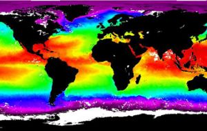
 Colorized global Sea Surfase Temperature map taken from NOAA
 The most recent El Niño, the periodic weather pattern that can have repercussions around the world from torrential rains and floods in the Americas and Africa to droughts and brush fires in Australia and Asia, has now ended and a transition to its mirror image, La Niña, is a substantial possibility, according to the latest United Nations forecast.
Both phenomena refer to large-scale changes in sea-surface temperature across the central and eastern tropical Pacific, with a warm pool located in the central and western Pacific expanding to cover the tropics during El Niño but shrinking to the west during La Niña. Thus La Niña (or cold episodes) produces the opposite climate variations from El Niño. For example, parts of Australia and Indonesia are prone to drought during El Niño but are typically wetter than normal during La Niña. "The observed rate of cooling has been more rapid than most models predicted," the UN World Meteorological Organization said in its latest update. "Currently, several, but not all, models indicate the likelihood of an emerging La Niña over the next several months." WMO cautioned that forecasts made at this time of year "notoriously lack skill" and the March-May period is often referred to as the "spring barrier" in the predictability of El Niño and La Niña, but there are indications that cooler than normal waters may prevail over the next several weeks in the central and eastern Equatorial Pacific such that a La Niña event becomes established. In such an event, given the timing in the year, the phenomenon would likely persist for much of the remainder of the year. Experts have noted the presence of a substantial pool of cooler than normal water just beneath the surface of the central and eastern Equatorial Pacific and this is expected to reinforce, over the next few weeks, the already cooler than normal waters at the surface. "The system at this time of the year is finely balanced and can be quite easily deflected from an apparent track, but the pre-requisite conditions appear to be in place for the development of a La Niña event," WMO said. "The next 2-3 months will be crucial for determining whether neutral conditions continue, or a La Niña event does indeed transpire." El Niño conditions, which in December were forecast as likely to persist until at least March, dissipated rapidly during January and February. Prior to that climate patterns over several months displayed many characteristics usually associated with El Niño, including drier than normal conditions across many parts of Australia, Indonesia and Fiji, unusually heavy rains and flooding across parts of eastern Africa, and extended dry spells across many south-western parts of southern Africa.


Top Comments
Disclaimer & comment rulesCommenting for this story is now closed.
If you have a Facebook account, become a fan and comment on our Facebook Page!