MercoPress. South Atlantic News Agency


Survey of massive mountain range below Antarctic ice
 Dr Fausto Ferraccioli
 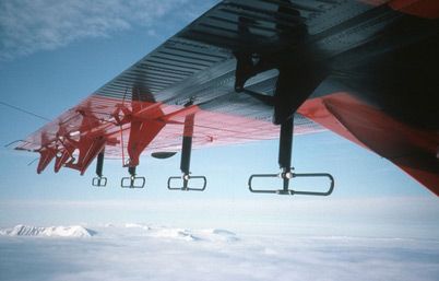 The ice penetrating radar attached to the Twin Otter aircraft wing
 A massive yet enigmatic mountain range as big as the Alps lying deep beneath Antarctica's ice has been surveyed in detail for the first time. The expedition, one of the most ambitious and challenging during International Polar Year, has captured the first clear picture of the mysterious Gamburtsev sub-glacial mountains.
The seven-nation team of researchers set out last November on a geophysical mission to capture the first glimpse of a landscape buried under up to four kilometers of ice. They have just returned to the UK with data showing that some of the mountain peaks may be less than 500 meters below the surface of the ice. The Gamburtsev mountain range was discovered in 1958 during International Geophysical Year by a Soviet Antarctic expedition and named after Grigoriy Gamburtsev, a Russian geophysicist. It is positioned deep in East Antarctica, lying below the highest, and the coldest place on the East Antarctic Ice Sheet - Dome A. Researchers think they could be the birthplace of the vast East Antarctic Ice Sheet that covers 10 million km2 of our planet - an area the size of the United States. The mountains are unusual because they are situated in the heart of Antarctica. Ranges like the Himalayas, Andes and Rockies form when continents collide and crunching tectonic plates force peaks upwards. This explanation does not fit easily with what polar researchers know about the Gamburtsev range. Mountains can also form above volcanic hotspots like Hawaii, but so far, no volcanic activity has been found in the region. Geologist Dr Fausto Ferraccioli from the British Antarctic Survey said, 'We really can't understand what these mountains are doing in the centre. It really is an enigma.' Working for weeks at high altitude the science teams set up two remote field camps on both sides of Dome A. In some of the harshest conditions imaginable with temperatures averaging -30?C, the researchers flew two survey aircraft over the ice sheet. The aircraft covered 120,000 km, the equivalent of three trips around the globe. Over 20% of the East Antarctic Ice Sheet was explored with state-of-the-art radar, aeromagnetic and gravity sensors. Ferraccioli said, 'This is a fantastic finale to the International Polar Year. The most interesting thing about our findings is that there definitely is a huge mountain range beneath the ice. Before this expedition we only knew of its existence from quite sparse information taken during the Russian expedition.' 'Now we know the morphology of it is similar to the Alps. There are incredible peaks and troughs. And this adds even more mystery about how the vast East Antarctic Ice Sheet formed,' he added. 'This is the nucleation point for the East Antarctic Ice Sheet - the largest ice sheet on the planet. If the ice sheet grew slowly then we would expect to see the mountains eroded into a plateau shape. But the presence of peaks and valleys could suggest that the ice sheet formed quickly - we just don't know. Our big challenge now is to dive into the data to get a better understanding of what happened.' The expedition, named the Antarctica Gamburtsev Project or AGAP, involved researchers from the UK, the US, Germany, Australia, China and Japan. AGAP US Co-leader Dr Robin Bell, of the Lamont-Doherty Earth Observatory at Columbia University said, 'The temperatures at our camps hovered around -30 Celsius, but three kilometers beneath us at the bottom of the ice sheet we saw liquid water in the valleys. The radar mounted on the wings of the aircraft transmitted energy through the thick ice and let us know that it was much warmer at the base of the ice sheet.' As well as mapping the Gamburtsev Mountains and its sub glacial lakes, the science team also traced ancient ice layers using radar data. This will help determine the ideal location for future deep ice coring, which will provide novel insights into past, present and future climate change. Ferraccioli describes the project as the first page in a book. 'Think about how much research has been done on the Alps. We know a great deal about how they formed. But we know next to nothing about this range.' The researchers plan to hold a joint UK-China conference in Cambridge to discuss initial findings and present the first results at the American Geophysical Union's fall meeting. Pictures credit: BC

Top Comments
Disclaimer & comment rulesCommenting for this story is now closed.
If you have a Facebook account, become a fan and comment on our Facebook Page!