MercoPress. South Atlantic News Agency


NASA and Argentina launching satellite to measure salt levels at ocean surface
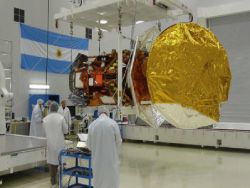 Scientists preparing the satellite for Thursday launching
Scientists are launching an international mission to measure salt levels at the surface of the ocean. A rocket carrying an Argentine-built spacecraft is set to lift off Thursday from the Vandenberg Air Force Base along the central California coast.
The spacecraft carries a NASA-built instrument Aquarius that will map weekly changes in ocean salt levels. Understanding the varying salt concentration at the ocean surface will help researchers better predict future climate change and other short-term events.
The mission is a collaboration between NASA and Argentina's space agency, Comision Nacional de Actividades Espaciales (CONAE), with participation from Brazil, Canada, France and Italy. SAC stands for Satelite de Applicaciones Cientificas. Aquarius was built by NASA's Jet Propulsion Laboratory in Pasadena, Calif., and the agency's Goddard Space Flight Centre in Greenbelt, Md.
In addition to Aquarius, the observatory carries seven other instruments that will collect environmental data for a wide range of applications, including studies of natural hazards, air quality, land processes and epidemiology.
The mission will make NASA's first space observations of the concentration of dissolved salt at the ocean surface. Aquarius' observations will reveal how salinity variations influence ocean circulation, trace the path of freshwater around our planet, and help drive Earth's climate. The ocean surface constantly exchanges water and heat with Earth's atmosphere. Approximately 80% of the global water cycle that moves freshwater from the ocean to the atmosphere to the land and back to the ocean happens over the ocean.
Salinity plays a key role in these exchanges. By tracking changes in ocean surface salinity, Aquarius will monitor variations in the water cycle caused by evaporation and precipitation over the ocean, river runoff, and the freezing and melting of sea ice.
Salinity also makes seawater denser, causing it to sink, where it becomes part of deep, interconnected ocean currents. This deep ocean “conveyor belt” moves water masses and heat from the tropics to the Polar Regions, helping to regulate Earth's climate.
“Salinity is the glue that bonds two major components of Earth's complex climate system: ocean circulation and the global water cycle,” said Aquarius Principal Investigator Gary Lagerloef of Earth & Space Research in Seattle. “Aquarius will map global variations in salinity in unprecedented detail, leading to new discoveries that will improve our ability to predict future climate.”
Aquarius will map the entire open ocean every seven days for at least three years from 657 kilometres above Earth. Its measurements will produce monthly estimates of ocean surface salinity with a spatial resolution of 150 kilometres. The data will reveal how salinity changes over time and from one part of the ocean to another.
The Aquarius/SAC-D mission continues NASA and CONAE's 17-year partnership. NASA provided launch vehicles and operations for three SAC satellite missions and science instruments for two.

Top Comments
Disclaimer & comment rules-

-

-

Read all commentsThese are the news worth reading from my country !!
Jun 07th, 2011 - 01:43 pm 0Good job Cristina!!
Jun 07th, 2011 - 05:58 pm 0whatever Marcos !!
Jun 07th, 2011 - 06:01 pm 0Commenting for this story is now closed.
If you have a Facebook account, become a fan and comment on our Facebook Page!