MercoPress. South Atlantic News Agency
Falklands' maps and 'The Times' report manipulated in Argentine embassy pamphlets
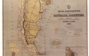
 Original version of the Latzina map of 1882, the first official Argentine map produced after the Boundary Treaty of 1881
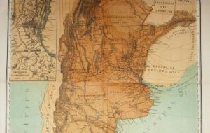
  Manipulated version of the Latzina map
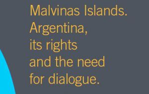
  The Argentine pamphlet produced by the Argentine embassy which collects the manipulated maps and newspaper report
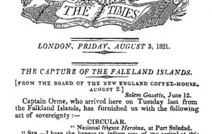
  The Times, 3 August 1821 announcing David Jewett’s actions in claiming the Falkland Islands for Argentina.
 By Justin A Kuntz - There are many examples of the power of social media to quickly form and mould world opinion. One recent example is that of Dr Tim Hunt, a Nobel Prize winner, whose professional reputation was utterly destroyed on Twitter whilst airborne during a return flight from Korea. Increasingly social media is also seen as a crucial communication tool for politicians and opinion makers to master.
Thirty-three years after the end of the Falklands War, a bitter conflict is being waged in Cyberspace to manipulate world opinion over the Falkland Islands dispute. Among the revelations of Edward Snowden was the claim that the Foreign and Commonwealth Office intended to launch Operation Quito to influence Latin American opinion on the Falkland Islands. If such an operation were ever launched, then it appears to have been a dismal failure.
Argentina has also sought to use social media to influence world opinion in its favour but some of its methods are perhaps less subtle. Examples include the deliberate manipulation of original historic maps to bolster the Argentine claim. Cartography played a key role in the Beagle Channel dispute, since rather embarrassingly official Argentine maps showed the disputed islands as Chilean. Equally embarrassing for its Falklands’ claim, those same maps also show the Falkland Islands as foreign territory.
One such map is the Latzina map of 1882, the first official Argentine map produced after the Boundary Treaty of 1881. Intended to be used to attract immigration to Argentina 120,000 copies were produced in numerous languages. Commentators on social media make the bold claim that the map shows the Falklands as Argentine territory.
Comparing the maps circulating on social media with the original, it is plain that some crude manipulation has changed the shading to match the Falklands and Argentine territory. The attempt has been somewhat botched in that some of the original colour has been retained and the key still shows the original colours. However, the perpetrator has thought to remove all meta information from the file that could give away their identity. Meta information is the hidden information in an image file that gives details of the camera used and crucially that of image manipulation programs.
Equally crude is the manipulation of the story in The Times of 3 August 1821, announcing David Jewett’s actions in claiming the Falkland Islands for Argentina. This ran as a minor news item at the bottom of page 2. In a pamphlet produced by the Argentine embassy, this small story now appears to have been prominently shown on the front page. Historically this would have been inaccurate in any case, since in those days the front page principally carried advertisements
Both images have now made their way into Wikipedia. The Spanish Wikipedia prominently displays the manipulated copy of The Times, accompanied by the standard Argentine claims over the announcement. Argentine users of Wikipedia have also sought to replace copies of the Latzina map with the manipulated version. But why Wikipedia? The online encyclopedia is often used by journalists to quickly check facts on a story and there are examples where copy has been lifted directly from the encyclopedia anyone can edit.
Both of these examples are so crude and easily shown to be false that the effectiveness of this campaign to manipulate world opinion is questionable. However, Snowden’s claims concerning Operation Quito offer a convenient smokescreen. In a classic example of cognitive dissonance, the manipulated Argentine versions are accepted as the true version and the legend of Operation Quito enables the originals to be dismissed as a British false flag operation. Perhaps the real motives are simply to manipulate opinion in Argentina itself, as is often the case in Argentina where the Falkland Islands are concerned.


Top Comments
Disclaimer & comment rules-

-

-

Read all commentsHahaha, you must be joking. Yeah, this time you must be joking. First the info is wrong it was a british intelligence task group not the FCO. And i didnt know that Snowden has liberated this “Argentine cover operation”?
Nov 06th, 2015 - 07:29 pm 0Now that we are talking about intelligence operations. How is that this Supposedly Uruguayan news agency has no Uruguayan Editor, nor any Uruguayan journalist?. And what is worst, has articles signed by a british teenager that has no idea where Uruguay is located.
Of course im not saying either this is a MI6 operation with Justin Kunz as a british agent, nothing far from the truth. But come on!!! Its a poor excuse to justify the british dirty operations.
Thanks Mr Kuntz and thanks Mercopress for your totally non-biased and totally not one sided reporting yet again.
Nov 06th, 2015 - 07:38 pm 0UK right, Argentina wrong, no operation to influence opinion, got ya.
British Falkland Islands.
Nov 06th, 2015 - 07:49 pm 0that's all that is needed .
Commenting for this story is now closed.
If you have a Facebook account, become a fan and comment on our Facebook Page!