MercoPress. South Atlantic News Agency
HMS Protector opens 2016/17 season in South Georgia surveying 160 sq miles of seabed
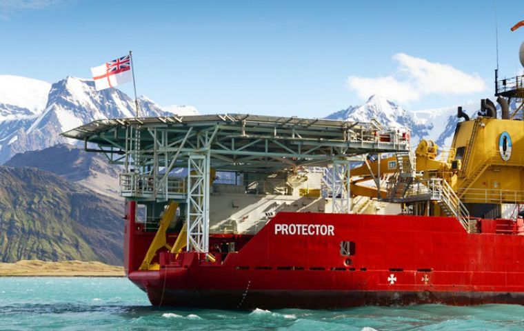
 During her stint around South Georgia the Plymouth-based icebreaker/survey ship scanned 160 square miles of seabed – roughly the area of the Isle of the Wight. (Pic RN)
 Having spent last Antarctic summer celebrating the deeds of one British polar hero, the crew of Royal Navy icebreaker HMS Protector have opened the 2016-17 survey season honoring his rival. A century after Sir Ernest Shackleton landed at King Haakon Bay on South Georgia in a makeshift lifeboat – the James Caird – Protector entered the same fjord and sent her hi-tech survey launch – the James Caird IV – close to the identical spot.
In May 1916, Shackleton’s landing was followed by a 36-hour trek over the island’s mountains to the whaling station at Stromness, where he finally alerted the world to the plight of his expedition; every man in his expedition party trapped on Elephant Island, 800 miles away, was eventually rescued.
One hundred years later and Protector’s Royal Marines detachment led some of the ship’s company on the final six kilometers of Shackleton’s 32km walk from Fortuna Bay into a now-abandoned Stromness.
“It was a privilege to be able to follow in the footsteps of Sir Ernest Shackleton – if only for a short distance” said Marine Tom Colwill.
“The weather going over the ridge was amazing and we had fantastic views. Once we reached Stromness the fog closed in and we had a short taste of the conditions the original expedition may have experienced.”
Weapon engineer LET(WE) Andy Conway added: “This was an amazing day, probably one of the best of my career so far.”
With whaling long gone, South Georgia has been re-born as a remote nature haven and an increasingly-popular destination for eco-tourists; during the summer season (April-September) upwards of 10,000 people now visit the island.
As a result, the charts cruise liners use to negotiate its rocky waters need to be bang up to date, so Protector and her hi-tech survey launches such as James Caird IV gathered the latest data on the seabed.
During her stint around South Georgia the Plymouth-based icebreaker/survey ship scanned 160 square miles of seabed – roughly the area of the Isle of the Wight. The reams of data collected will be fed by the UK Hydrographic Office in Taunton to allow it to update the charts used by the Royal Navy – and many of the world’s mariners.
Protector is now beginning her second austral summer surveying Antarctic waters and supporting scientific studies. During the 2015-16 season, she concentrated her efforts in the Ross Sea – last visited by a Royal Navy vessels eight decades ago and the focal point for Capt Scott’s attempts to reach the South Pole.
In visiting Capt Scott’s former haunts, Protector has also visited many of his arch rival’s; in the 12 months since the ship left the UK, she has visited almost all of the key locations associated with Shackleton’s polar expeditions: Lyttelton in New Zealand, his hut on the Ross Ice Shelf, the abandoned whaling stations of South Georgia and the Antarctic gateway port of Punta Arenas, Chile where Shackleton and his men were ultimately rescued with assistance from the Chilean Navy.


Top Comments
Disclaimer & comment rules-

-

Read all commentsGood old Royal Navy, keep up the good work.
Nov 10th, 2016 - 01:44 pm 0September to April season would be more pleasant in the southern hemisphere
Nov 11th, 2016 - 06:00 pm 0Commenting for this story is now closed.
If you have a Facebook account, become a fan and comment on our Facebook Page!