MercoPress. South Atlantic News Agency
Falklands using drones to create fine scale models of minefields
 One of the drones being used to map Stanley’s minefields (SAERI)
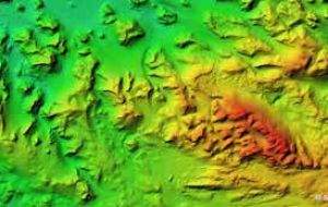
  Digital terrain model created with the help of SafeLane Global for the same area as the image above. (SAERI)
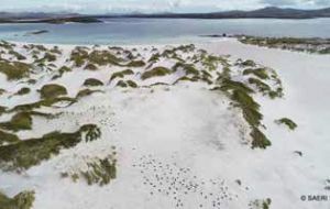
 View across Yorke Bay minefield from drone (SAERI)
The minefields around the Falkland Islands capital, Stanley, dating back to the South Atlantic conflict, have remained largely untouched for most of nearly 35 years, due to the restrictions in place around access to the minefields. Over this time, they have become a haven for Falkland’s wildlife.
The fact that following the demining process, these areas will be opened to the public by Falkland Island Government, albeit allowing for suitable habitat recovery, generated interest amongst stakeholders involved in the Darwin + Coastal Habitat Mapping project currently underway within the Falklands and South Georgia.
They saw an opportunity to map these areas prior to the demining process, allowing the project to capture a baseline of what these pristine habitats looked like, so that future change could be monitored.
Since October 2018, Neil Golding, the Coastal Habitat Mapping Project Manager at the South Atlantic Environmental Research Institute (SAERI), has been out to Yorke Bay and the surrounding area with SafeLane Global personnel, capturing imagery with drones to create state of the art maps of these minefields.
Neil realized there was an opportunity to create a better product with wider utility through collaborating with the UK Government Falkland Islands Demining Program, led by Guy Marot of Fenix Insight, and SafeLane Global who undertake the clearance work.
As part of this collaboration, SafeLane Global deployed markers (known as Ground Control Points) actually within the minefields and then took their positions and heights using specialist survey equipment.
Neil then used this information during the processing of the drone imagery to create highly accurate digital terrain models of the minefields.
The models are a useful addition to the work already undertaken by SafeLane as part of the demining process.
The Coastal Habitat Mapping project is currently working to feed this high resolution drone imagery into a habitat modeling process in order to develop fine scale habitat maps for the coastal margins of the Falkland Islands. These fine-scale habitat models/ maps are scheduled for completion by the end of June 2019.
Neil said: “Being able to work with the Falklands Demining Program has been a fantastic opportunity, and the project is grateful for the support Dave Clark and the SafeLane Global survey team has been able to provide, not forgetting Ross Chaloner from the Public Works Department.
The resulting aerial maps not only provide an excellent baseline to monitor change after the project and land has been handed back, but have also hopefully provided SafeLane with valuable additional information for their work”.
John Hare, Technical Director at SafeLane Global said “this supplementary piece of work provides really good corroborative, and in some cases additional, data and a bench mark for the remediation of the minefield sites”.
Historically, and to this day, the coastal and inshore marine ecosystems and resources have played an important role in the Falkland Islands, both from a social and economic perspective. Knowledge of these coastal environments is essential for their management, yet comprehensive island-wide broad-scale and fine scale coastal habitat maps are lacking. Such maps would form an important baseline from which to measure future change.
The DPLUS065 Coastal Habitat Mapping project aims to fill this critical gap in coastal knowledge.
This three-year project, grant aided by the Darwin Initiative through UK Government funding, and with a financial contribution made by FIG through the Environmental Studies Budget, brings together many organizations.
These comprise SAERI, Oregon State University, the UK Joint Nature Conservation Committee, Shallow Marine Surveys Group, Falkland Islands Government and Government of South Georgia & the South Sandwich Islands, representing the leading edge in remote sensing, ecological knowledge and field expertise. The Coastal Habitat Mapping project is due to conclude in March 2020. (SAERI/Penguin News)


Top Comments
Disclaimer & comment rulesCommenting for this story is now closed.
If you have a Facebook account, become a fan and comment on our Facebook Page!