MercoPress. South Atlantic News Agency
Scientists find never-changing ice island in Antarctica
 Researchers reached this conclusion from color images from Landsat satellites between 1989 and 2022
 Climate change has been confirmed once more to be taking its toll on Earth's shape as an ice island has been discovered in Antarctica which has stayed unchanged even in the presence of bypassing icebergs and other phenomena, according to NASA data.
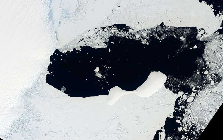
The new meteorological developments have been found on Antarctica's east coast on the Glenzer and Conger ice shelves, while also creating the conditions for the creation of an ice island that has remained immobile for 13 years despite the passage of time and iceberg impacts.
Researchers reached this conclusion from color images from Landsat satellites between 1989 and 2022. They detected the ice mound maintained the same characteristics and shapes even after the ice shelf broke off, and as the sea ice around it increased and decreased.
Technically, in order to speak of a new island, scientists still need to determine whether there is solid land beneath all the snow and ice. From the Australian Antarctic Division, John Gibson believes it is an ice island: a large, heavy ice sheet sitting solidly on an underwater peak “similar to other ice islands, such as Bowman Island.”
Gibson also defined it as “a self-perpetuating ice island,” meaning that the accumulation of snow and ice on the surface of the island balances the amount of melting that occurs underwater. If that balance is disrupted by a decrease in snowfall, then the ice island could thin and float away. “The unnamed island is a more or less permanent feature of the landscape,” Gibson said, “but someday it could break away from the underlying rock and become an iceberg,” he pointed out.
“To be absolutely sure, you'd need to put a ship next to it to check for bedrock outcropping, and maybe radar over it to assess the thickness of the ice,” said Christopher Shuman, a glaciologist at the University of Maryland at NASA's Goddard Space Flight Center.
“The ICESat-2 profile shows that the surface is well above sea level. That would be a lot of 'ice' over the 'cone' if there were no bedrock at or above sea level,” he added.
The “new” island is the latest in a group of similar features that are no longer embedded in Antarctica's floating glacial ice. In 2019, the U.S. Board on Geographic Names recognized Icebreaker Island, which in 1996 became isolated from the Larsen B ice shelf along the Antarctic Peninsula. And in 2020 researchers on a ship expedition discovered a small, rocky, ice-covered island that may have been part of the Pine Island Glacier ice shelf.
“The discovery of more of these is likely to continue in the coming years due to shrinking glaciers and sea ice,” Shuman said. “Obviously, these are 'new-to-us' features, but we also now have more people and more tools to observe the margins of Antarctica. Several examples do not set a trend, but they do imply that other once-hidden features are likely to be noticed in the years to come,” he added.


Top Comments
Disclaimer & comment rulesCommenting for this story is now closed.
If you have a Facebook account, become a fan and comment on our Facebook Page!