MercoPress. South Atlantic News Agency


Foul weather forecast for the weekend in Uruguay
 Noticeable improvements are not expected at least until Monday
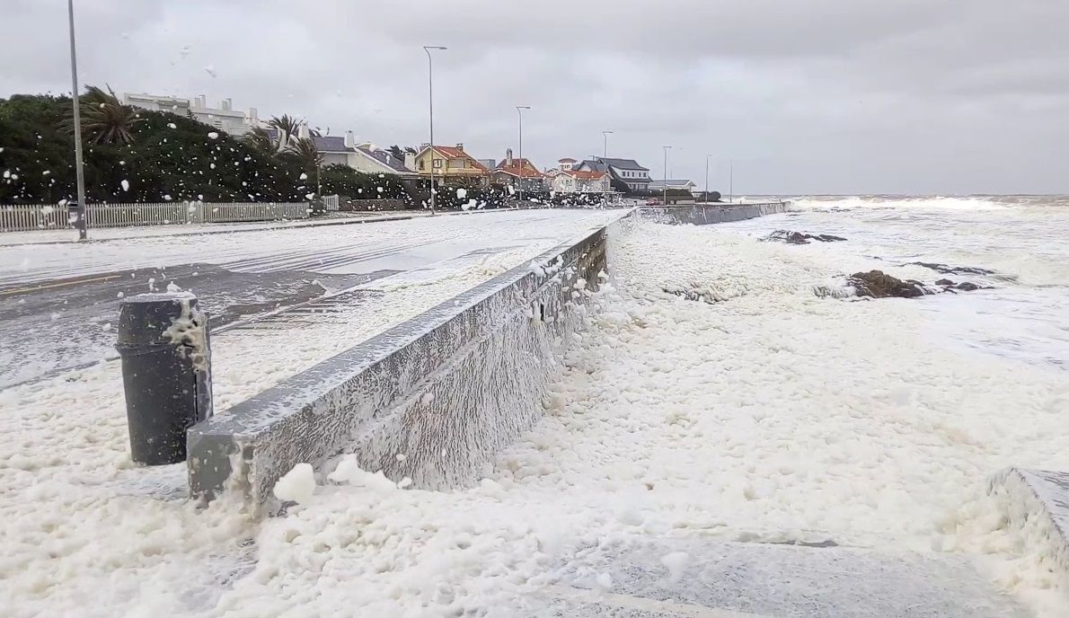
 An extratropical cyclone is expected to bring severe storms and heavy rainfall to Uruguay this coming weekend. According to meteorologist José Serra and the Uruguayan Institute of Meteorology (Inumet), this is a “natural and normal situation” for this time of year.
The phenomenon will begin on Friday as a humid, unstable air mass enters the country from the west. The most intense weather is predicted for Saturday and Sunday, with strong and potentially severe storms with strong winds, heavy rainfall, electrical activity, and possible hail.
The situation is expected to improve in the southwestern part of the country on Sunday, but storms will continue in the east and northeast until at least Monday. Inumet also noted that temperatures will drop on Sunday, recommending that people dress warmly.
“Starting Friday night, we will see the formation of an atmospheric depression, which will result in an extratropical cyclone or mid-latitude cyclone,” Serra said, as a low-pressure system of between 998 and 1000 hectopascals looms over, leading to the appearance of clouds, rain, and storms.
In the expert's broadcast opinion, severe storms are those accompanied by strong winds in the storm area, heavy and abundant rainfall in a short period of time, electrical activity, and a high probability of hail.
“From Saturday at dawn until Sunday morning across the country, but in the east-northeast and east of the territory, it will remain unstable until Monday inclusive. On Sunday, the situation will begin to improve in the southwest, with a decrease in cloud cover and the sun timidly making an appearance,” he also explained.
According to Inumet, Friday “will be a warm, humid, and unstable day” throughout the country. Saturday will be unstable, generating “occasionally strong storms” in the morning over the west and north coast. In the afternoon, the southwest will have “very strong” storms, which will “move east and northeast.”
An extratropical cyclone is a low-pressure weather system that forms outside the tropics, usually in mid-latitudes, between 30° and 60°. Unlike their tropical counterparts, these systems are not fueled by ocean heat. Their fundamental development mechanism lies in the temperature contrast between air masses with opposite characteristics, typically associated with the presence of atmospheric fronts.
These phenomena originate in regions where air masses of different temperatures interact, such as at the boundaries between cold polar air and warm subtropical air. Their internal structure includes warm and cold fronts, which is an essential difference from tropical cyclones, which lack them. They have an asymmetrical configuration, with a cold core in the upper levels of the atmosphere.
The energy that drives them derives mainly from temperature gradients, a process known as baroclinic, rather than from latent heat released by the ocean. In terms of size and scope, they are usually large-scale systems, covering hundreds or even thousands of kilometers. Their influence can affect large regions with strong winds, rain, snowfall, or various storms.
In the southern hemisphere, their influence is felt in areas such as southern Argentina, Chile, and Uruguay, where they often cause strong winds and precipitation of varying intensity.

Top Comments
Disclaimer & comment rulesCommenting for this story is now closed.
If you have a Facebook account, become a fan and comment on our Facebook Page!