MercoPress. South Atlantic News Agency
Colombia records its strongest earthquake in a decade, geological service says
 The quake struck at 07:34 local time (12:34 GMT), with its epicenter about five kilometers east of the municipality of San José del Palmar, in Chocó department, some 240 kilometers west of Bogotá
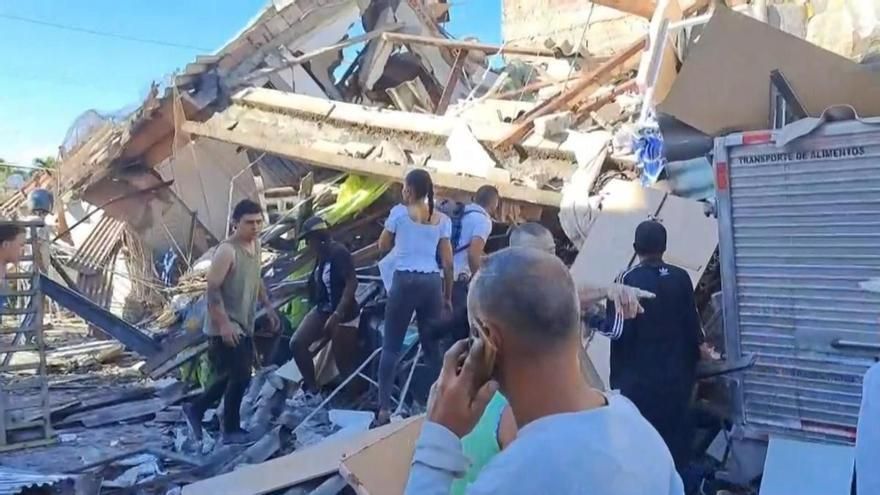
 A magnitude 7.4 earthquake shook western and central Colombia on Monday, causing damage in several cities and affecting six airports. It is the strongest earthquake recorded in the country in the past decade, according to the Colombian Geological Service (SGC). No official casualty figures have been released so far.
The quake struck at 07:34 local time (12:34 GMT), with its epicenter about five kilometers east of the municipality of San José del Palmar, in Chocó department, some 240 kilometers west of Bogotá. The SGC initially reported magnitudes of 6.6 and 6.7 before raising the figure to 7.4 in a later bulletin. The focus was located at more than 80 kilometers depth, an intermediate range that explains why the tremor was felt across such a wide area. The agency has recorded two aftershocks, of magnitude 2.8 and 4.8, the second widely felt.
Dios mio, protégenos #temblor pic.twitter.com/HAMsqHa9nA
— Capri (@dannann02) August 10, 2026
The earthquake was felt in Bogotá, Cali, Medellín, Popayán, Manizales, Armenia and Pereira, as well as in Panama, Ecuador and Venezuela. Buildings and hospitals were evacuated in the Panamanian capital. The National Disaster Risk Management Unit ruled out a tsunami threat along the Pacific coast.
In Manizales, one of the cathedral towers was severely damaged and left leaning against the main body of the church. At Pereira's Matecaña international airport, part of the roof came down in a passenger transit area. The civil aviation authority reported damage at the Pereira, Manizales, Quibdó, Armenia, Cartago and Buenaventura terminals and suspended air operations at all of them pending structural assessment.
In Cali, the country's third city, facades came away, buildings collapsed and power, gas and water services were cut. Firefighters and rescue teams deployed to inspect structures while the municipal risk management council carries out its damage assessment. Injuries have been reported in Quibdó and at Pereira airport, without confirmed figures.
El aeropuerto de Pereira quedó completamente destruido #Temblor #TobiNews pic.twitter.com/HREEiPQVSO
— Tobi (@Tob1P4xao) August 10, 2026
President Abelardo de la Espriella, who took office on Friday, ordered the establishment of a unified command post to coordinate the response and announced he would travel to Pereira. “You are not alone. The state is present and acting,” he wrote on his X account. He also requested a detailed report from the head of the national disaster risk management unit.
Colombia is one of the few countries in the world where three tectonic plates converge, and it records an average of 50,000 earthquakes a month, most of them imperceptible. The deadliest events in its recent history were the 1999 Armenia quake, magnitude 6.2 with close to 1,000 dead; the 1994 Páez quake, with about 800; and the 1983 Popayán quake, with 287.


Top Comments
Disclaimer & comment rulesCommenting for this story is now closed.
If you have a Facebook account, become a fan and comment on our Facebook Page!