MercoPress. South Atlantic News Agency


Wind fanned wildfires scorch California, half million evacuees
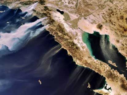 A European Space Agency photo shows desert winds blowing smoke from wildfires in Southern California
 US President George W Bush has declared California a major disaster zone after four days of wildfires sparked the biggest evacuation since Hurricane Katrina. The fires have killed five people, injured 40 and burned 1.500 homes, causing an estimated one billion US dollars in damage.
More than 500,000 people have been ordered to evacuate as fierce winds fan fast-moving fires that have ravaged land from Santa Barbara to Mexico. Forecasters say winds are weakening from highs of 100mph earlier in the week. California Governor Arnold Schwarzenegger praised the "great co-ordination" and also thanked President Bush for signing the disaster declaration, which will free federal funds to help governments, families and individuals recover from the devastation wrought by the blazes - at least 16 of which are still burning. "I will continue to make sure that our efforts are co-ordinated, and that we are responsive to the needs of people... we offer our prayers and hopes that all will turn out fine in the end," Mr Bush said. The US president is scheduled to visit the area Thursday. The head of the Federal Emergency Management Administration (Fema), David Paulison, said the government had learnt its lesson after it was accused of a sluggish response to Hurricane Katrina on the Gulf Coast two years ago. "What we see now that we did not see during Hurricane Katrina is a very good team effort from the local, the state and the federal government and across the federal agencies," Mr Paulison said. More than 162,000 hectares of land have been scorched - an area bigger than New York City - and 25,000 buildings are threatened. Forestry officials say the seasonal Santa Ana winds are hampering their efforts to contain fires raging across the state. In San Diego County, which has been hardest hit and where five blazes are still burning, the bill just from damage to homes will top one billion US dollars said San Diego County emergency services director Ron Lane. County officials placed evacuation calls to 346,000 homes, ordering about 560,000 people to leave - although some 50,000 were allowed to return late on Tuesday. In Orange County, officials said the number of fires had stretched resources to breaking point. More than 10,000 evacuees stayed overnight at Qualcomm Stadium in San Diego, while other residents sought shelter in schools, community centres and fairgrounds. Ambulances and school buses moved hundreds of people from hospitals, nursing homes and prisons. The blazes are the worst to hit California since 2003 wildfires that killed 22 people. Firefighters have been working around the clock in difficult conditions and are also employing new technologies with help from NASA. NASA announced that it will fly a remote plane, the Ikhana, over fire sites and take images of the blazes with a thermal-infrared imaging system developed at NASA's Ames Research Center. Capable of seeing through heavy smoke and darkness to see hot spots, flames and temperature differences, the system will transmit the data to a communications satellite at the center. "After processing, the images are transmitted through a communications satellite to NASA Ames, where the imagery is placed on an Ames Web site. Then the imagery is combined with Google Earth maps," spokesman Jim Brass said in a statement. Similarly, researchers in command centers have been developing fire behavior models to help fire managers better plan how to use their resources and, potentially, even which communities to evacuate next. Working out of a Southern California geographic center with other organizations, including the California Department of Forestry and Fire Protection, and the U.S. Park Service, the U.S. Forest Service runs computer programs that can predict a fire's life span, how fast it will grow and in what direction it will spread. The program, called FS Pro, produces digital maps of the fire's progress, "based on the weather forecast, what's burning ? the fuel ? and the topography," said Rob Seli, a fire behavior analyst at the Forest Service Rocky Mountain Research Station. Seli is part of a group that is working with the software to predict where some of the worst fires will be in the next few days. Although the original version of the imaging program has been around since 1994, the Forest Service only started using the newest version this summer. In the past, National Weather Service forecast information wasn't digitized and had to be loaded into the program by hand. Only now, has the software become practical to use. "That's one of the reasons we're testing this out ? to see if we can keep up with the speed of the fires," Seli said. "Recently, we've got a lot more nationwide data available to us. ? [We can] do these things quickly and easily, since the data is available now."

Top Comments
Disclaimer & comment rulesCommenting for this story is now closed.
If you have a Facebook account, become a fan and comment on our Facebook Page!