MercoPress. South Atlantic News Agency
Argentina continental shelf presentation includes Falklands
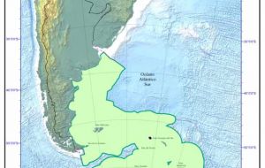
 Map shows Argentina's continental shelf claim
 Argentina officially presented this week before United Nations its continental shelf claims which if approved will extend the country’s sovereign limit on the sea bed from 200 to 350 miles. The request includes all those areas claimed by Argentina: Falklands/Malvinas, South Atlantic islands and the so called Argentine Antarctic Territory.
According to the Argentine press the sovereign rights claim involves an area equivalent to 1.7 millions square kilometres.
The presentation completed before the May deadline, was done by Deputy Foreign Affairs minister Vicotr Taccetti and includes areas “under dispute” with the United Kingdom and Chile, points out the Buenos Aires press reports.
The Argentine documentation in forty volumes weights 840 kilos resumes “eleven years of technical and scientific” work with the purpose of “defending our national sovereignty”.
The UN Convention on the Law of the Sea (UNCLOS) confers on all coastal States sovereign rights for the purpose of exploring and exploiting the natural resources of its continental shelf.
UNCLOS provides that each coastal State possesses as a matter of international law a continental shelf which extends to 200 nautical miles from the shoreline (regardless of whether or not a geological continental shelf exists that far).
In addition, Article 76 of UNCLOS provides for coastal States to seek to establish an extended outer limit to the continental shelf beyond 200 nautical miles, up to 350 nautical miles from its coastline, or 100 miles from where the sea reaches a depth of 2,500 metres, and where specified geological conditions exist.
For this purpose, the State is required to submit evidence to the Commission on the Limits of the Continental Shelf (CLCS), which will then make recommendations concerning the establishment of the outer limits of the State’s continental shelf.
According to the Argentine press Britain has not yet made any presentation regarding the Falkland Islands, South Georgia and South Sandwich islands.
“The UK has collected data but plans for the submission have not been finalized, and we are considering our approach in view of the May 2009 deadline” according to a recent report from the Foreign Office.
The FCO also revealed that UK has discussed the disputed areas issue with technical and legal experts from the Argentine Ministry of Foreign Affairs in 2001 and 2004, “with a view to making a joint submission without prejudice to rival sovereignty claims”. However, despite a UK proposal for a further meeting in 2007, “no further bilateral meetings have taken place”, said FCO.
Regarding Antarctica, the right to an extended continental shelf under the UN Law of the Sea has to be considered against the provisions of the Antarctic Treaty, which put all territorial claims in abeyance.
However the UK in May 2008 notified the CLCS that it was not submitting data for the continental shelf of the British Antarctic Territories, but that it reserved the right to do so in the future.
Furthermore in cases where a dispute exists (Falklands, South Georgia) between the coastal States concerned, the Rules of Procedure of the CLCS require it to decline to examine any submission which would prejudice delimitation between them without the agreement of the States concerned.
Ideally, the States concerned will agree on a common approach before submitting to the Commission. The best solution in such areas may be for the States concerned to make a joint submission, or at least separate but complementary submissions. This would set the outer limits of the extended continental shelf, leaving the coastal States to draw up internal boundaries between themselves at a later date.


Top Comments
Disclaimer & comment rules-

-

-

Read all commentsthanks UN & peaceful way, we will recover the Malvinas. “Principle of territorial integrity”.
Apr 22nd, 2009 - 07:39 pm 0www.panoramio.com/photo/21366907
Apr 22nd, 2009 - 07:41 pm 0Yet another back-door juvenile tactic from the Argentine Government. Precisely what do they hope to achieve, besides discord? This application is quite obvioulsy going to be denied.
Apr 22nd, 2009 - 08:04 pm 0By the way, the map (from Telam, an official source) grossly misinforms the reader as to the projected territory. The distance between South Geogria and the Falklands is 720 miles, between SG and the Antarctic peninsula is 750 miles. So how precisely is Argentina planning on stealing those 20 and 50 additional miles?
Further evidence of the unjustified and totally illegal enthusiasm for Argentine expansionism.
Thankfully, it's going nowhere.
Commenting for this story is now closed.
If you have a Facebook account, become a fan and comment on our Facebook Page!