MercoPress. South Atlantic News Agency

Ice losses in both caskets and rising sea level faster than estimated
 Sea level rising 3 mm per year, should reach 15 cm by 2050
 Ice loss from Antarctica and Greenland has accelerated over the last 20 years, research shows, and will soon become the biggest driver of sea level rise. From satellite data and climate models, scientists calculate that the two polar ice sheets are losing enough ice to raise sea levels by 1.3mm each year.
Overall, sea levels are rising by about 3mm per year. Writing in Geophysical Research Letters, the team says ice loss here is speeding up faster than models predict.
They add their voices to several other studies that have concluded sea levels will rise faster than projected by the Intergovernmental Panel on Climate Change (IPCC) in its landmark 2007 assessment.
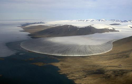
By 2006, the Greenland and Antarctic sheets were losing a combined mass of 475Gt (gigatonnes - billion tonnes) of ice per year.
On average, loss from the Greenland sheet is increasing by nearly 22Gt per year, while the much larger and colder Antarctic sheet is shedding an additional 14.5Gt each year.
If these increases persist, water from the two polar ice sheets could have added 15cm to the average global sea level by 2050. A rise of similar size is projected to come from a combination of melt water from mountain glaciers and thermal expansion of seawater.
“That ice sheets will dominate future sea level rise is not surprising - they hold a lot more ice mass than mountain glaciers,” said lead author Eric Rignot from Nasa's Jet Propulsion Laboratory (JPL) in Pasadena, California.
“What is surprising is this increased contribution by the ice sheets is already happening.”
Extending this rate of ice loss forward to 2100, the sea level rise contribution from the two ice sheets alone is calculated at 56cm.
The twin Grace satellites orbit the Earth in close formation, detecting tiny variations in gravity.
By contrast, the IPCC in 2007 projected a maximum rise of 59cm, while acknowledging this was likely to be an under-estimate because understanding of processes happening on ice sheets was insufficient to enable reliable estimates to be made.
Since 2007, several other research groups using different methods have concluded that a figure between one and two metres is likely - which would have profound consequences for island nations and countries with long, low coastlines such as Bangladesh.
“If present trends continue, sea level is likely to be significantly higher than levels projected by the IPCC,” said Dr Rignot. “Our study helps reduce uncertainties in near-term projections of sea level rise.”
The new research combined two different methodologies.
One calculates ice gain and loss through combining various types of satellite reading and data taken on the ground, for example the thickness of the ice sheet and the speed at which glaciers are moving.
The second dataset comes from NASA Grace mission which uses twin satellites to measure variations in the Earth's gravitational pull. Ice loss causes a fractional reduction in gravity at that point on the Earth's surface.
Two years ago, this mission surprised some in the research community by showing that even the vast and frigid East Antarctic ice sheet was losing some of its mass to the oceans. (BBC).-

Top Comments
Disclaimer & comment rules-

-

Read all commentsSea level is not rising by 3mm a year. This false figure arose in one fell swoop to double that of the tide gauges when they changed from tide gauges to satellite measurements in 1992, using the Topex satellite. The satellite cannot measure sea level when there is any land within the footprint because cannot tell land echoes from sea echoes and gives a false result. This means that all sea areas within 3 to 5 kilometres of continental coasts, islands, even atolls, are not covered. Also not covered is all oceanic area north of 66°N or south of 66°S, due to the angled track of the satellite. This results in the Arctic Ocean and the high-latitude part of the North Atlantic being excluded. Also excluded is much of the oceanic area surrounding Antarctica. Yet the claim of 3.2 mm is the one being advanced as demonstrating increasing sea level rise. These lies are endless. The Grace satellites also have problems and have not been in operation long enough for any meaningful conclusions to be drawn.
Mar 10th, 2011 - 12:02 pm 0There was no significant increase in the rate of sea level rise over the past century. In 2007 S. J. Holgate of the Proudman Oceanographic Laboratory, Liverpool, UK, showed that the rates of sea level change observed over the past 20 years were not particularly unusual when compared to nearly continuous sea level records around the world for 1904–2003.” It was published in Geophysical Research Letters, vol 34, 2007.
His research demonstrated that “The rate of sea level change was larger in the early part of last century in comparison with the latter part.” Mean sea level rise was 1.74 mm per year, or just under seven inches for the whole century. “
Dennis (#1), you question the impact of ice-sheet melt on sea level. I have no problem with variance in estimates of impact on sea level for reasons some of which you identify.
Mar 10th, 2011 - 03:45 pm 0I have some fundimental belief, however, that ice sheets ARE nett-melting atm. Liquid water follows its gravitational track to the sea and sooner or later affects the current condition. It may be simple water mass/volume change, water temperature/profile/current distribution, or it may be fertility/biosphere change ....... probably all of these and more.
The thing that really bothers me is RATE OF CHANGE.
Commenting for this story is now closed.
If you have a Facebook account, become a fan and comment on our Facebook Page!