MercoPress. South Atlantic News Agency


Falklands, South Atlantic islands, Antarctica included in new Tierra del Fuego official map
 Governor Fabiana Rios sent the bill for approval by the provincial legislative in Ushuaia, most probably with the blessings from Buenos Aires
 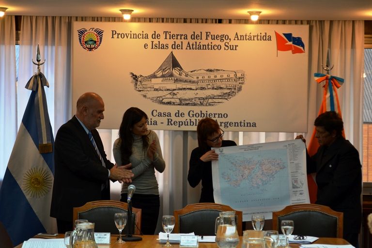 The official presentation of the new map which redesigns the political limits into four Departments, one which includes the Falklands and another, Argentine Antarctica
  Ushuaia is the political capital of Tierra del Fuego, Antarctica and South Atlantic Islands, and the hub for cruises to the southern seas
 Argentina's most southern province identified as Tierra del Fuego, Antarctica and South Atlantic islands is redesigning its internal political limits with the purpose of “contributing to the territorial sovereignty of the Nation”, according to a bill sent to the provincial legislative by governor Fabiana Ríos and drafted with help from the Malvinas Question Advisory Observatory.
According to the Ushuaia daily, Diario del Fin del Mundo, the bill establishes the political division of the province into four departments: Rio Grande, Ushuaia, South Atlantic Islands, which includes Falklands and South Georgia, and Antarctica.
The South Atlantic Islands Department includes the Falklands/Malvinas Islands, Beauchene island, the Coromoran and Negra rocks, South Georgia, South Sandwich islands, other islands, islets and rocks in the interior waters and territorial sea generated by those territories according to Law 23.968, which refers to Argentina's Territorial Sea.
The Argentine Antarctica Department is to extend from Parallel 60 to the North to the South Pole in the South. Meridian 25 East and Meridian 74 West.
Rio Grande Department has the north limit at the Magellan Strait, and to the south, from the international Argentine-Chilean limit at a point in 54º33'00' latitude South to the mouth of river Turbio at 54º33'00' south and 67º15'00' longitude W, following along the same parallel until Irigoyen river, at meridian 66º35'31' longitude W to continue along its northern margin until the mouth at the Atlantic ocean, at 54º31'25' latitude S and 66º16'07' longitude W.
The East limit extends from Cape Espiritu Santo, all along the Atlantic ocean until the mouth of river Irigoyen at 54º31'25' S and 66º16'07' longitude W.
To the West, the international Argentine-Chilean limit from Cape Espiritu Santo up to 54º33'00' latitude S. It includes all islands, islets, rocks in interior waters and in the Argentine territorial sea generated by the above territories and in accordance with Law 23.968 (Argentine Territorial Sea), until the border with Chile.
Department of Ushuaia, has to the north the interior limit with Rio Grande Department and the Atlantic ocean. To the East, the coasts along the Atlantic ocean. To the West, the international border with Chile from point 54º33'00' latitude S until the international Argentine-Chilean border on the Beagle Channel. To the south, the Atlantic ocean and the Argentine-Chilean limit at the Beagle Channel. The Department also includes the islands of the States, el New Year archipelago, other islands, islets and rocks in interior waters and the territorial sea generated from those territories in accordance with Law 23.968, as well as the islands, islets and rocks to the south of Tierra del Fuego Isla Grande to the limit with Chile.
The bill adds that all geodesic values are expressed in the Argentine Reference System POSGAR '07.
Finally the Land Registry and Territorial Information Office from Tierra del Fuego will be responsible for the elaboration of the official maps, besides the mandatory use of all this information and maps at all levels of Argentina's education system (as mandated by Law 26.206) as well as the public exhibition in all provincial offices and dependencies of the Tierra del Fuego, Antarctica and South Atlantic islands of the official map.
Top Comments
Disclaimer & comment rules-

-

-

Read all commentsProphetic.
Apr 08th, 2015 - 04:28 pm 0After Argtardia collapses for the third time this century (I give it about 10-15 years after the current lollercaust plays out), the Falklands will probably end up divvying Tierra del Fuego up with Chile.
Thanks for the fail, Argtards :)
Go force and prosper retards whats the reason for the claim on south georgia and the sandwhich islands anyway?
Apr 08th, 2015 - 04:41 pm 0The 'Malvinzing' of reality, the truth and the facts continues apace in Agenzuela. Viva la Patria!
Apr 08th, 2015 - 04:50 pm 0More bread and circus for these bananas.
Commenting for this story is now closed.
If you have a Facebook account, become a fan and comment on our Facebook Page!