MercoPress. South Atlantic News Agency


Nepal and China agree that Mount Everest is 86cm higher: 8,848.86m
 Employing trigonometry hundreds of kilometers away on the Indian plains, British geographers first determined Everest's height in 1856 at 8,840m above sea level.
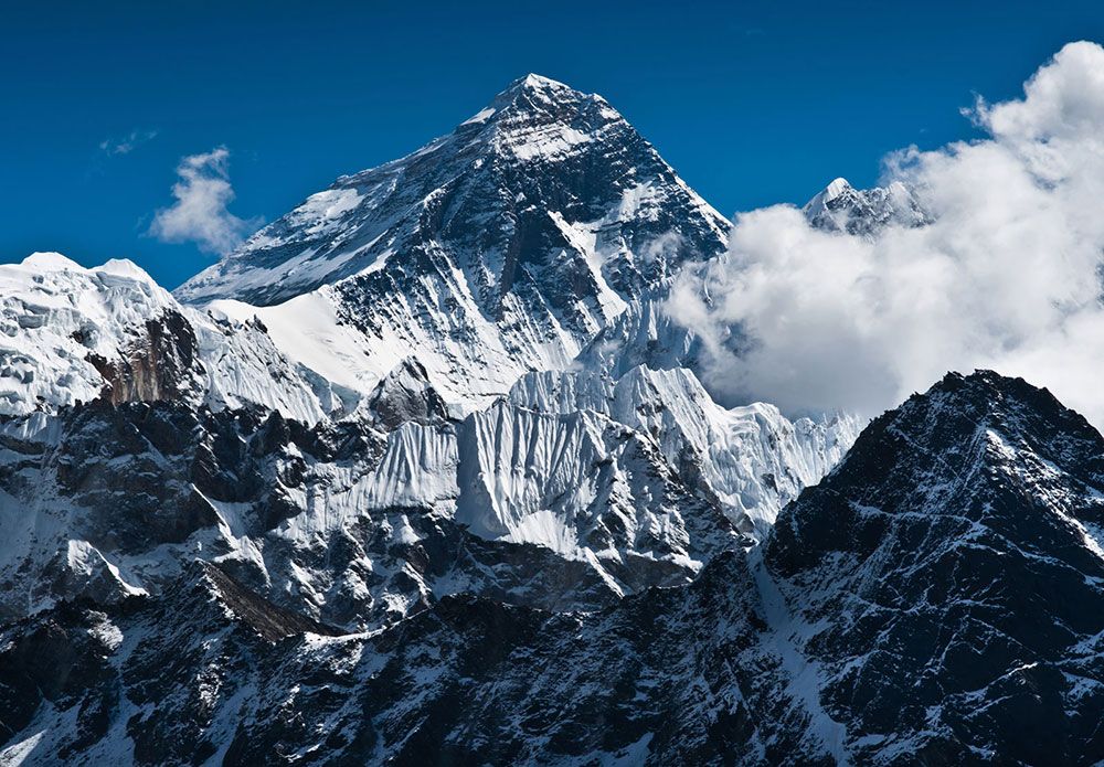
  After Edmund Hillary and Tenzing Norgay Sherpa first reached the summit of Everest on May 29, 1953, an Indian survey readjusted the altitude to 8,848m.
 The highest point on Earth got a bit higher on Tuesday as China and Nepal finally agreed on a precise elevation for Mount Everest after decades of debate. The agreed height unveiled at a joint news conference in Kathmandu of 8,848.86m is 86cm higher than the measurement previously recognized by Nepal, and more than 4m above China's official figure.
The discrepancy was due to China measuring the rock base on the summit and not - as with the new reading - the covering of snow and ice on the peak.
Employing trigonometry hundreds of kilometers away on the Indian plains, British colonial geographers first determined Everest's height in 1856 at 8,840m above sea level.
After Edmund Hillary and Tenzing Norgay Sherpa famously first reached the summit of Everest on May 29, 1953, an Indian survey readjusted the altitude to 8,848m.
That measurement was widely accepted, with the number alluring not just ambitious mountaineers, but also inspiring names for adventure clothing lines, restaurants and even a vodka.
In 1999, the US National Geographic Society concluded that the world's highest point was higher, at 8,850m. But Nepal never officially recognized this new height, although it is widely quoted.
China, meanwhile, conducted several surveys, and in 2005 came up with its measurement of 8,844.43m.
That provoked a row with Nepal which was resolved only in 2010 when Kathmandu and Beijing agreed that their measurements referred to different things - one to the height of Everest's rock and the other to the height of its snowcap.
Nepal decided to conduct the survey - the first time it has done its own - after suggestions that tectonic plate movements, including a major earthquake in 2015, may have affected the height.
About 300 Nepali experts and surveyors were involved in the exercise, some walking on foot, with others using helicopters to reach data collection stations.
Last spring, Nepali surveyors reached the summit of Everest with over 40kg of equipment, including a Global Satellite Navigation System (GNSS) receiver.
They spent roughly two freezing hours collecting data as dozens of climbers stood on top of the mountain.
“Climbing Everest alone is a challenging task, but we also had to measure it,” said Mr Khim Lal Gautam, a Survey Department official who lost a toe to frostbite in the expedition.
Nepal was due to release the results earlier this year but then China became involved after a visit to Nepal in October 2019 by Chinese President Xi Jinping.
Mr Dang Yamin, an expert at the National Bureau of Surveying and Mapping, told Chinese state broadcaster CCTV that the final result was an average value between the measurements by Nepal and China, in accordance with scientific rules.
“The final height was concluded after both sides jointly shared and processed data virtually,” said Mr Damodar Dhakal, a spokesman for Nepal's Department of Survey.
Top Comments
Disclaimer & comment rulesCommenting for this story is now closed.
If you have a Facebook account, become a fan and comment on our Facebook Page!