MercoPress. South Atlantic News Agency
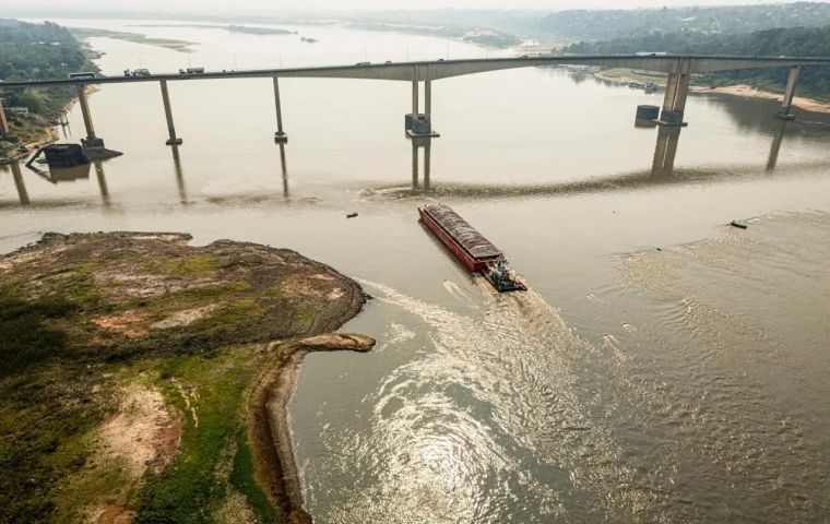
Paraguay River hits all-time lows in Brazil
 Every river in the Paraguay Basin stood below average levels for this time of year, except the Cuiabá River thanks to flows being regulated by the Manso Hydroelectric Plant
 The Brazilian Geological Survey (SGB) found that the Paraguay River was 62 centimeters below its reference level, the lowest level ever measured at the Ladario post, near the city of Corumbá (MS), on the border with Porto Quijarro (Bolivia), thus surpassing the 61 cms recorded in 1964, Agencia Brasil reported.
The standard level is an average depth of 5 meters (m), according to the Mato Grosso do Sul Environment Institute (Imasul), which had already warned of the river's lowest historical level last Wednesday. The station serves as a reference for the Brazilian Navy when analyzing conditions for navigation and defining restrictive measures.
The Paraguay River flows through the states of Mato Grosso, where it rises, and Mato Grosso do Sul, from where it flows to Paraguay and Argentina. Its springs are fed by waters from the Amazon, a region also facing a historic drought.
According to the National Water Agency (ANA), the Paraguay Hydrographic Region occupies 4.3% of Brazilian territory, covering part of the states of Mato Grosso and Mato Grosso do Sul, which includes most of Mato Grosso's Pantanal, the largest continuous wetland area on the planet.
For the SGB, the situation had been expected since February, when researchers warned of the possibility of reaching a historic low in the region. “This drought has been observed due to below-normal rainfall throughout the rainy season, since October 2023. That's why we've been warning about this process that was unfolding in the basin,” researcher Marcus Suassuna said in an SGB statement.
According to Imasul, the drop in the level of the Paraguay River has direct implications for the economy and the environment, affecting tourism and fishing, as well as the supply of riverside communities. Experts associate this drastic reduction with climate variability and the lack of rainfall in the river basin. The Pantanal, one of the most fragile and important biomes on the planet, is particularly vulnerable to these changes, which affect both biodiversity and human communities.“
According to SGB projections, the recovery of levels in the Paraguay River Basin will be slow. The level at Ladario should remain below par until the second half of November. ”We've noticed that the river's rate of descent has slowed considerably and has been stabilized since last Monday (7) due to the first rains of the rainy season. Rainfall should continue, but not at a very strong rate that will contribute to rapid rises in this stretch and throughout the basin,” Suassuna pointed out.
The decade has been marked by insufficient rainy seasons for the recovery of reserves. The SGB also found that during the rainy season that began in October 2023 an accumulated deficit of 395 (millimeters) mm of rain was recorded. The estimated total was 702 mm, while the expected average was 1,097 mm. In the decade, considering the accumulated from 2020 to 2024, the deficit was approximately 1,020 mm, equivalent to the total of one hydrological year.
Also according to the SGB report, the Paraguay River Basin recorded 3 mm of rain last week, with all of the region's rivers below average levels for this time of year, except the Cuiabá River, which stood within normal projections thanks to the regularization of flows by the operation of the Manso Hydroelectric Plant.
In Barra do Bugres and Porto Murtinho, the Paraguay River reached its lowest level in the entire series of monitoring stations. The study explains that the projections used indicate accumulated rainfall of 27 mm in the coming weeks, leading to the beginning of the recovery of levels in Cáceres, Ladário, Forte Coimbra, and Porto Murtinho, as well as stabilization in other places.
According to the National Electric System Operator (ONS), considering the estimate for Affluent Natural Energy (ENA), the Southern Region should reach 86% of the Long Term Average (MLT). This measure indicates the capacity of hydroelectric generation systems. For the other regions, the indices are as follows: North, with 49% of the MLT; Southeast/Central-West, with 45%; and Northeast, with 34%.
The Brazilian Navy also warned about the worsening navigation conditions for the Paraguay River: “Due to the rigid drought regime observed on the Paraguay River and the consequent outcropping of sandbanks and rocks, navigators should redouble their attention, using the nautical chart in force, paying attention to the beacon and maintaining a safe speed.”
The region has seen constant boat traffic since at least the 18th century, establishing an important integration corridor with neighboring countries. Today it is one of the six waterways whose bidding process for concession to the private sector has been established as a priority by the National Waterway Transportation Agency (ANTAQ), along with the Madeira, Tapajós, Tocantins, Lagoa Mirim, and Barra Norte waterways. The project aims to speed up the transport of cargo, especially agricultural and mineral production, for processing and export, which should favor the increased exploitation of these items in the region, activities that lead to increased water consumption.


Top Comments
Disclaimer & comment rules-

Read all commentsSo far this year, Brazil has seen the lowest ever level in the Paraguay River, the worst ever floods, worst ever drought and also its worst ever storm, and still two and a half months to go.
Oct 14th, 2024 - 03:58 pm 0Perhaps a plan to start drastically cutting GHG emissions immediately, before large parts of Brazil become uninhabitable.
Or perhaps not, just keep following the yellow brick road.
Commenting for this story is now closed.
If you have a Facebook account, become a fan and comment on our Facebook Page!