MercoPress. South Atlantic News Agency
Tag: Aqua satellite
-
Wednesday, January 31st 2018 - 09:29 UTC
NASA satellite keeps track of wildfires in Argentina
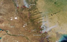
Roughly 12,000 wildfires burn each year in Argentina, charring more than 1.3 million hectares (5,000 square miles) of forest and grasslands. The Moderate Resolution Imaging Spectroradiometer (MODIS) on NASA’s Aqua satellite captured an image of one of them on January 29, 2018.