MercoPress. South Atlantic News Agency
Tag: James Clark Ross
-
Saturday, June 11th 2022 - 10:00 UTC
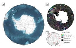
After five years of work, new seafloor map of the Southern Ocean covering 48 million sq Km

A new map of the seafloor of the Southern Ocean surrounding Antarctica provides the most accurate representation of this vast area to date. The International Bathymetric Chart of the Southern Ocean (IBSCO) has taken five years to compile and update this map, which was first published in 2013.
-
Friday, November 6th 2020 - 09:16 UTC
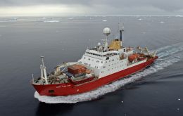
RRS James Clark Ross left Harwich for summer mission in Antarctica

The RRS James Clark Ross left the Port of Harwich on Thursday beginning its five-and-a-half-month mission to deliver scientific and operational staff to Antarctica and to resupply the UK stations in Antarctica for another year.
-
Friday, May 10th 2013 - 07:23 UTC
Falklands’ denies political impact of Argentine South Georgia scientific cruise

News this week that Argentina had decided to undertake fisheries research in the South Georgia and South Sandwich Islands (SGSSI) is not connected in any way to the Falklands, Acting Governor Sandra Tyler-Haywood has assured.
