MercoPress. South Atlantic News Agency
Tag: Signy Research station
-
Saturday, February 15th 2025 - 20:26 UTC
New map of South Orkney Islands published for the first time in 40 years by BAS
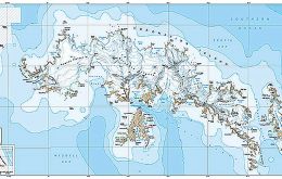
A new map of the South Orkney Islands has been released by British Antarctic Survey (BAS) – the first UK published, topographic map of the region in almost 40 years. Created by the Mapping and Geographic Information Centre at BAS, the map offers a detailed topographic view of the entire South Orkney archipelago on one side, with a focused, high-resolution map of Signy Island on the reverse.
-
Thursday, March 24th 2022 - 09:30 UTC
Signy Research station 75th anniversary; RRS Sir David Attenborough visit
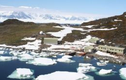
This week RRS Sir David Attenborough visited South Georgia arriving at the upgraded wharf for the first time at King Edward Point marking a new chapter for polar science