MercoPress. South Atlantic News Agency
IAATO expedition vessel helps HCA chart Antarctic waters
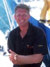 Stephen Wilkins, skipper of the yacht Xplore
 An IAATO sailing yacht has demonstrated that private and commercial vessels on expeditions in Antarctica can perform official hydrographic surveys and produce navigational charts that are still much needed for the region. Results were presented at the 13th Conference of the Hydrographic Commission on Antarctica (HCA) in Cadiz, Spain 3-5 December, hosted by the Spanish Navy.
Surveys were conducted by Stephen Wilkins, skipper of the yacht Xplore in response to the limited availability of navigational data in Antarctica, some of which dates as far back as the early 1900s and, like many areas of the world, does not comply with the latest international standards set by the 81 countries of the International Hydrographic Organization (IHO).
Wilkins regularly conducts bespoke expeditions to the southern continent and is a representative of the International Association of Antarctica Tour Operators (IAATO). IAATO in turn actively supports the work of the IHO through its HCA, which strives to improve and coordinate surveying and charting activity in Antarctica.
“We were told that it was impossible for a leisure sailing vessel to perform IHO standard surveys with a multi-beam sonar in Antarctica because of the many challenges involved. However, thanks to the French Hydrographic Office, SHOM, providing a surveyor and Sky Ring Marine in Chile in cooperation with Reson providing a suitable sonar and other support, we proved not only that it could it be done but that the data could be included in charts soon after. Navigational charts can typically take years to produce following a survey, but ours are already available for other navigators”, said Wilkins.
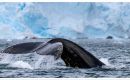
During the seven-day survey in January 2013, Xplore and her team surveyed 15.2 square nautical miles including identifying and accurately positioning a shoal which had been marked as “position doubtful”. This has since been officially named “SHOM Rock” to thank the French Hydrographic Office for their support in the project.
Dr Kim Crosbie, Executive Director of IAATO said “the costs and difficulties of working in the remote Antarctic environment often limits the abilities of countries to conduct surveys. With regular visits each year by IAATO member vessels, which often have small auxiliary craft and other vessels that can safely access shallow water areas, there is real scope to work collaboratively with Hydrographic Offices in improving our knowledge of the sea floor and continue to strengthen safe navigation for shipping. This is one of the reasons why we work closely with the IHO and the HCA”
Representatives from the national Hydrographic Offices of 15 countries with interests in Antarctica attended the HCA Conference in Cadiz. Of importance was prioritizing which regions in Antarctica are in most need of surveying and better charting, and then coordinating which national Hydrographic Offices will take the lead for improving the charts in those areas.
A short film illustrating the Xplore/SHOM survey available at: http://www.tv.reson.com/video/8153079/
IAATO is a member organization founded in 1991 to advocate, promote and practice safe and environmentally responsible private-sector travel to the Antarctic. IAATO currently has 110 members.
The International Hydrographic Organization (IHO), founded in 1921 and with headquarters in Monaco, is the intergovernmental technical and consultative organization whose principal aim is to ensure that all the world’s seas, oceans and navigable waterways are properly surveyed and charted. The IHO comprises 81member countries -each usually represented by its national Hydrographer or authority charged with responsibility for hydrography and charting in each country. The IHO is the competent authority for hydrography and charting at the UN. Its international standards on hydrography and charting are always referred to in relevant UN instruments and Conventions. All the world’s nautical charts use IHO standards.
Stephen Wilkins (Xplore Expeditions) is a qualified merchant mariner and professional sailor. He has been conducting expeditions to the polar regions since 2003. Yoann Boulaire (SHOM) is a professional hydrographer and has been working in SHOM hydrographic and oceanographic vessels since 2008. SHOM is the French Hydrographic Office. Fernando Landeta is a hydrographic technician with Sky Ring Marine Chile who provided the Reson multi-beam sonar.
Top Comments
Disclaimer & comment rulesCommenting for this story is now closed.
If you have a Facebook account, become a fan and comment on our Facebook Page!