MercoPress. South Atlantic News Agency
Tag: Signy Island
-
Saturday, February 15th 2025 - 20:26 UTC
New map of South Orkney Islands published for the first time in 40 years by BAS
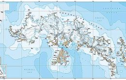
A new map of the South Orkney Islands has been released by British Antarctic Survey (BAS) – the first UK published, topographic map of the region in almost 40 years. Created by the Mapping and Geographic Information Centre at BAS, the map offers a detailed topographic view of the entire South Orkney archipelago on one side, with a focused, high-resolution map of Signy Island on the reverse.
-
Thursday, April 30th 2020 - 07:55 UTC
Plastic pollution continues to reach sub-Antarctic islands

Food wrapping, fishing gear and plastic waste continue to reach the Antarctic. Two new studies into how plastic debris is reaching sub-Antarctic islands are published in the journal Environment International.
-
Wednesday, April 8th 2020 - 18:30 UTC
BAS ends Antarctic season and organizing the return: chartered ship will leave Falklands for UK 3 May

British Antarctic Survey (BAS) has announced exceptional plans to repatriate scientists, support teams and construction workers as they complete their Antarctic summer field season work.
-
Monday, March 6th 2017 - 10:53 UTC
UK's Signy Station on South Orkney Islands, hottest place in Antarctica
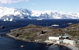
A World Meteorological Organization (WMO) committee of experts announced on March first, new records for the highest temperatures recorded in the Antarctic Region. The results are part of continuing efforts to expand a database of extreme weather and climate conditions throughout the world.
-
Tuesday, November 1st 2016 - 14:21 UTC
Gentoo penguins proving to be the sturdiest in Antarctica

A forty year study on a remote Antarctic island shows that while populations of two penguin species are declining, while a third is increasing. Analysis of census data from Signy Island in the South Orkney Islands reveals that, between 1978 and 2016, the number of chinstrap penguin pairs declined by nearly 70%.