MercoPress. South Atlantic News Agency
Tag: Cold wave
-
Thursday, July 9th 2026 - 05:03 UTC
Argentina's polar spell eases as Patagonia faces rain, snow and 90 km/h gusts
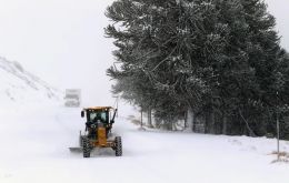
The intense polar air mass that affected much of Argentina during the first days of July has begun to ease, with a gradual rise in temperatures across the center and north of the country, while Patagonia now concentrates the most severe weather. The National Meteorological Service (SMN) has kept warnings in place for rain, snow and strong winds in the far south.
-
Friday, July 3rd 2026 - 07:47 UTC
Snow blankets Mar del Plata as a record polar cold wave grips Argentina
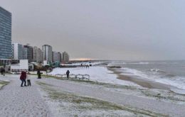
The seaside city of Mar del Plata, one of the main tourist destinations on Argentina's Atlantic coast, woke up covered in snow on Thursday, an unusual sight for a temperate-climate city that became the most widely shared image of the intense polar cold wave sweeping the country. Thermometers read around 1 degree below zero, with a wind-chill close to -3 °C, and snow and sleet were recorded from the early hours in various parts of the General Pueyrredón district, with heavier accumulation in the Sierra de los Padres area.
-
Wednesday, July 10th 2024 - 20:10 UTC
Uruguay: Cold wave warning amid “extreme temperatures”

The Uruguayan Institute of Meteorology (Inumet) has extended its cold wave warning until Friday, July 12, citing “extreme temperatures” affecting most of the country. The updated forecast predicts minimum temperatures between -6 ºC and 2 ºC and maximum temperatures ranging from 8 ºC to 12 ºC.